How do I verify land survey accuracy?
Want to know the fastest, most reliable way to verify land survey accuracy in Milton, ON and avoid costly legal headaches?
Why verifying a land survey matters in Milton
Milton is growing fast. New subdivisions, infill lots, and changing zoning mean boundaries and legal documents get tested. A bad survey can sink a sale, delay a permit or cost you thousands in boundary disputes. This guide shows exactly how to verify land survey accuracy in Milton, Ontario — step by step, no guesswork.
Quick answer: the 7-point verification checklist
- Confirm the surveyor’s licence and AOLS stamp.
- Check the survey date and compare to municipal records.
- Match bearings, distances and calls to the registered plan or deed.
- Verify on-site monuments and markers.
- Cross-check with Land Registry Office (Teranet) title and plans.
- Look for registered easements, rights-of-way and encroachments.
- Get written certification from a professional land surveyor.
Read on for exactly how to do each step and what to demand from the surveyor.
Step 1 — Verify the professional who did the work
Ask for the surveyor’s name, licence number and Association of Ontario Land Surveyors (AOLS) stamp. In Ontario only a licensed Ontario Land Surveyor (OLS) can certify plans for registration. The AOLS stamp and licence number must appear on the plan. If it’s missing, stop. Don’t rely on verbal claims.
Why this matters: an unlicensed practitioner can produce an invalid survey. That invalidates permits and weakens your legal position.
Step 2 — Check the survey date and context
A survey older than 5–10 years may not reflect recent subdivisions, condo conversions, or municipal changes in Milton. Compare the survey date to:
- The date on the property deed or transfer documents.
- The date of the last registered plan in the Land Registry Office (LRO).
- Recent site changes: detached house additions, retaining walls, or new roads.
If the survey predates municipal approvals or construction, order an updated survey.
Step 3 — Confirm bearings, distances, and calls against the title
A boundary survey must match the legal description in the deed or registered plan. Look for:
- Matching bearings (N/S/E/W) and distances.
- Ties to known control points or block corners.
- Correct plan number and part numbers (for plans of subdivision or provincial plans).
If numbers don’t match, ask the surveyor for an explanation and a corrected plan. Don’t accept “approximate” answers.
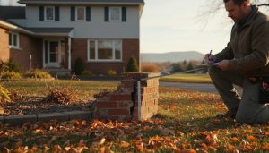
Step 4 — Inspect monuments and on-site markers
A proper boundary survey locates physical monuments: iron bars, wooden stakes, concrete monuments, or municipal control monuments. On-site verification steps:
- Ask the surveyor to show field photos and GPS coordinates of the monuments.
- Confirm visible markers at corners and important reference points.
- If a monument can’t be found, get a written statement explaining why and how the boundary was established instead.
Monuments are evidence. If they’re missing or moved, get clarification in writing.

Step 5 — Cross-check with Land Registry Office and municipal records
Milton is in the Regional Municipality of Halton. Use these sources:
- Teranet/OnLand (Land Registry Office) for registered plans, deeds and historical instruments.
- Halton Region and Town of Milton planning department for municipal approvals, lot grading and development records.
- MPAC property data for assessed boundaries (note: MPAC is not definitive legal evidence).
Pull the registered plan and confirm the plan number and part descriptions match the survey. Discrepancies matter.
Step 6 — Identify easements, rights-of-way and encumbrances
A survey should reveal all registered items that affect use and title: easements, rights-of-way, restrictive covenants, utility corridors. In Milton common items include:
- Utility easements for Halton Hills Hydro, Enbridge or telecommunications.
- Stormwater or lot grading agreements in subdivisions.
- Shared driveways or party wall agreements for infill properties.
If any encumbrance is missing from the survey, ask the surveyor to locate and show it on the plan and tie it to the title.
Step 7 — Demand clear written certification
A survey must include a surveyor’s certificate that clearly states what was done and how. The certificate should include:
- The surveyor’s signature, licence number and AOLS stamp.
- A statement of reliance (who can rely on the survey).
- The method used (GPS, total station, historical records) and any limitations.
- Clear depiction of what is measured (boundaries) versus shown for convenience (setbacks, features).
No certificate = no legal confidence.
Technical checks buyers and lawyers should insist on
- Ask for PDF and CAD/DWG files. CAD files let you overlay the survey with municipal maps and other plans.
- Request coordinates in NAD83/CSRS or the datum used. This enables accurate GIS checks.
- Confirm ties to OLS monuments or municipal control points. Without ties, the survey is weaker.
- Look for a revision block. If the survey was revised to correct errors, make sure changes are documented.

Common red flags in Milton properties
- Survey age: subdivisions in Milton have changed quickly since the 2010s.
- Missing easements for stormwater management in new neighbourhoods.
- Encroachments where fences, sheds or additions cross the legal line.
- Historic irregular lot lines in older Milton neighbourhoods with “part lot” descriptions.
If you see any red flags, get a targeted re-survey or legal review.
How this ties into legal documentation and closing in Milton
Real estate lawyers rely on accurate surveys for title insurance, closing statements, mortgage approvals and compliance with municipal permits. If a survey is inaccurate or incomplete:
- Title insurance insurers may exclude coverage for boundary issues.
- Municipal building permits could be revoked or delayed.
- Purchasers inherit risk of encroachments or easements not shown on the deed.
A clear, certified survey prevents these problems and speeds up closings.
Practical checklist to give your surveyor or lawyer
- Provide the deed, PIN and registered plan number.
- Request an Ontario Land Surveyor (OLS) with Milton/ Halton experience.
- Ask for both the signed paper plan and digital CAD files.
- Require a written statement on monuments located or lost.
- Confirm the surveyor will provide a letter of reliance for lenders or title insurers.
Cost and timeline expectations for Milton
- Typical boundary survey in Milton: $1,200–$3,500 depending on lot size and complexity.
- Subdivision or condominium surveys cost more and take longer.
- Turnaround: 1–3 weeks for a standard residential lot; faster for urgent closings with a premium.
If you need a fast review for a conditional offer, request a priority review and expect higher fees.

How Tony Sousa helps Milton clients (short, direct)
Tony reviews surveys, connects you with licensed Ontario Land Surveyors who know Milton and Halton Region, and coordinates with lawyers and title insurers so you can close with confidence. He reads the fine print, checks the plan numbers, and spots red flags before offers become costly mistakes.
Contact: tony@sousasells.ca | 416-477-2620 | https://www.sousasells.ca
FAQ — Land survey accuracy and legal documentation in Milton, Ontario
Q: Who can provide a legal land survey in Ontario?
A: Only a licensed Ontario Land Surveyor (OLS) can provide certified surveys for registration.
Q: How do I confirm an OLS licence?
A: Verify the surveyor’s AOLS stamp and licence number on the plan. You can confirm the licence with the Association of Ontario Land Surveyors.
Q: Is an old survey legally valid?
A: It can be, but it may not reflect recent changes. Compare the survey date to municipal plans and registered instruments. If changes occurred, get an update.
Q: What if the physical monument is missing?
A: The surveyor should document attempts to find it and explain the method used to re-establish the corner. Request a written statement.
Q: How do I check registered easements and rights-of-way?
A: Pull the title and registered instruments from Teranet/OnLand and compare to the survey. The survey should show and tie into any registered encumbrance.
Q: Can a surveyor resolve a boundary dispute?
A: A surveyor can locate boundaries and provide expert evidence, but enforcement or resolution may require legal action.
Q: Will title insurance cover boundary errors?
A: Title insurance policies vary. Insurers rely on certified surveys. Ask your insurer what exclusions apply and provide the certified survey before closing.
Q: How long does a re-survey take in Milton?
A: Usually 1–3 weeks for a residential lot. Complex cases take longer.
Q: What should my lawyer check regarding the survey?
A: The lawyer should confirm plan numbers match title, easements are shown, the surveyor’s certificate is present, and any discrepancies are resolved before closing.
Q: Who pays for the survey in a sale?
A: Typically the buyer pays for a new survey, but this can be negotiated. For mortgages, lenders may require a recent survey or title insurance.
Need an expert review of a land survey in Milton? Tony Sousa reads the details so you don’t inherit risk. Contact tony@sousasells.ca or call 416-477-2620 to get a fast, practical survey review and trusted referrals to licensed OLS professionals.